|
hidden
|
Areas
AREAS (Okrug), adm./territorial units introduced in the USSR by the first Soviet adm./territorial division reform (1923-29). The reform was developed by the Gosplan (State organization for the economic planning) and consisted in cancellation of the... more
|
|
|
|
hidden
|
Boksitogorsk District
BOKSITOGORSK DISTRICT, a part of Leningrad Oblast. Population: 34,800. Area: 7163 sq. km. Adm. center: Boksitogorsk Town. The district comprises Yefimovsky urban settlement and 275 inhabited localities. It borders Tikhvin District of Leningrad... more
|
|
|
|
hidden
|
Cherepovets Gubernia, the
CHEREPOVETS GUBERNIA, adm. and territorial unit with the center in the city of Cherepovets in the North-West of Russia in the early 20th century. The resolution to establish C. G. was adopted in 1918 at the meeting of representatives of five... more
|
|
|
hidden
|
Finland
FINLAND, country in Northern Europe. Borders Sweden, Norway, the RF (Murmansk Oblast, Republic of Karelia, Leningrad Oblast.) Located on the coasts of the Gulf of Bothnia and Gulf of Finland, Baltic Sea. Area: 338,000 sq. km (abt. 10% being inland... more
|
|
|
|
hidden
|
Gatchina District
GATCHINA DISTRICT, municipal entity. Population: 111,600. Area: 2850.3 sq. km. Established in 1927. Due to renaming of Gatchina Town, it was called Trotsk District in 1927-29, and Krasnogvardeisk District in 1929-44.Gatchina district borders with... more
|
|
|
|
hidden
|
Grand Principality of Finland*, v. Finland
reference
|
|
|
hidden
|
Ingermanland Gubernia*, v. Sankt-Peterburg Gubernia
reference
|
|
|
hidden
|
Ingermanlandia
INGERMANLANDIA (Swed. Ingermanland, Rus. Izhora Land or Ingria), historic and cultural region in the western part of the Leningrad Oblast (Kingisepp, Volosovo, Lomonosov, Vsevolozhsk, Gatchina, Tosno, western part of Kirovsk Districts.) The western... more
|
|
|
|
hidden
|
Kingisepp District
KINGISEPP DISTRICT, a part of Leningrad Oblast. Population: 74,300, of which, 52,100 live in the adm. center Kingisepp Town. Area: 2842.1 sq. km. It has 191 rural settlements. It was established in 1927.It borders with Lomonosov, Volosovo, and... more
|
|
|
|
hidden
|
Kirishi District
KIRISHI DISTRICT, a part of Leningrad Oblast. Area: 3009 sq. km. Population: 67,700. In the west, it borders Tosno, in the north-west, Kirovsk, in the north, Volkhov, and in the east, Tikhvin Districts of Leningrad Oblast; in the south-east, with... more
|
|
|
|
hidden
|
Kirovsk District
KIROVSK DISTRICT, a part of Leningrad Oblast. Area: 2590.9 sq. km. Population: 97,000. Located in the central part of Leningrad Oblast. In the north, it borders the Lake Ladoga coast; in the north-west and west, Vsevolozhsk District, in the west,... more
|
|
|
|
hidden
|
Lodeynoye Pole District
LODEYNOYE POLE DISTRICT, a part of Leningrad Oblast located east of Lake Ladoga in the Svir River basin. In the north-west and north, it borders Olonets District of the Republic of Karelia; in the north-east and east, Podporozhye District; in the... more
|
|
|
|
hidden
|
Lomonosov District
LOMONOSOV DISTRICT. Area: 1990.8 sq. km. Population: 65,300. Established in 1927. L. D. comprises Bolshaya Izhora and Lebyazhye urban settlements and 140 rural localities. It borders St. Petersburg and Kingisepp, Volosovo, and Gatchina Districts of... more
|
|
|
|
hidden
|
Luga District
LUGA DISTRICT, municipal entity. Population: 44,600. Area: 5993.1 sq. km. Located in the south of Leningrad Oblast. In the west, it borders Slantsy District, in the north, Volosovo, Gatchina, and Tosno Districts of Leningrad Oblast; in the east,... more
|
|
|
|
hidden
|
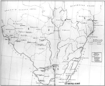
Novgorod Gubernia, the
NOVGOROD GUBERNIA, adm. and territorial unit in the north-west of Russia in the 18th – early 20th centuries. It was established in 1727 to comprise five provinces of St. Petersburg Gubernia: Novgorod, Pskov, Velikiye Luki, Tver, and Belozersk. In... more
|
|
|
|
hidden
|
Obonezhye
OBONEZHYE, historic and cultural region in the north-west of the European Russia. It included lands around Lake Onega. A part of the state of Novgorod: written sources from the 12th century mention the Obonezhskaya Hundred as an adm. and territorial... more
|
|
|
|
hidden
|
Olonets Gubernia, the
OLONETS GUBERNIA, adm. and territorial unit in the North-West of Russia in the late 18th – early 20th century. Olonets Province (Oblast) was established in1773, with Olonets as its center. In 1776, the province was added to the new-established... more
|
|
|
|
hidden
|
Podporozhye District
PODPOROZHYE DISTRICT, municipal entity. Population: 35,200. Area: 7705.5 sq. km. Located in the north-east of Leningrad Oblast. In the north-west and north, it borders Olonets, Pryazha, and Prionezhsky Districts of the Republic of Karelia; in the... more
|
|
|
|
hidden
|
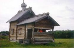
Pogosts
POGOSTS, a term widely used in the 10th – 18th centuries to designate territorial divisions and settlements; its meaning changed with time. P. was the term for the centers of rural communities that paid tribute to the Prince; place of tribute ... more
|
|
|
hidden
|
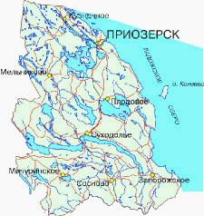
Priozersk District
PRIOZERSK DISTRICT, municipal entity. Population: 63,300 (of these, 20,500 live in Priozersk town, the adm. center.) Area: 3,563.1 sq. km. Located in the eastern and north-eastern parts of the Karelian Isthmus. It borders Vsevolozhsk and Vyborg... more
|
|
|
|
hidden
|
Pyatinas
PYATINAS, adm. and territorial regions of the core Novgorod Land as part of a united Russian State in the late 15th – 17th century. They are known from written sources (scribe rolls and deeds) from the late 15th century. There were five P.... more
|
|
|
|
hidden
|
Rural Councils
VILLAGE SOVIETS, lower-level adm. and territorial units, parts of districts. They were established everywhere in the USSR during the first Soviet reform of adm./territorial division in 1923-29, according to which, the previous three-level division... more
|
|
|
|
hidden
|
Slantsi District
SLANTSY DISTRICT, a part of Leningrad Oblast. Population: 2,200 sq. km. Population: 47,900. S. D. comprises Slantsy Town (adm. center) and 155 rural localities. It borders Kingisepp, Volosovo, and Luga Districts of Leningrad Oblast, Gdov District... more
|
|
|
|
hidden
|
Tikhvin District
TIKHVIN DISTRICT, municipal entity. Population: 14,600. Area: 6997.5 sq. km. Adm. center: Tikhvin Town. The district comprises 198 rural localities united into 8 rural settlements. It is located in the east and south-east of Leningrad Oblast. It... more
|
|
|
|
hidden
|
Tosno District
TOSNO DISTRICT, municipal entity. Located in the south of the central part of Leningrad Oblast, bordering Gatchina District in the west, St. Petersburg in the north-west, Kirovsk District in the north-north-west, Kirishi District in the east,... more
|
|
|
|
hidden
|
Union of Communes of the Northen Oblast
UNION OF COMMUNES OF THE NORTHERN OBLAST (UCNO), an oblast association of Soviets in 1918-19. It included Petrograd, Novgorod, Pskov, Olonets, Archangel, Vologda, North Dvina (separated from Archangel Gubernia in June 1918), and Cherepovets... more
|
|
|
|
hidden
|
Uyezds
UYEZDS, adm. and territorial units in Rus from the 13th century uniting several volosts and governed by Governors General. In the 15th – 16th centuries, in the course of rise of the united Russian State, they became the core link of the... more
|
|
|
hidden
|
Vodskaya Land
VODSKAYA LAND (Votskaya Land), historic, cultural, and administrative region of the middle-age Rus, located in the north-western part of Veliky Novgorod’s lands (western part of the current Leningrad Oblast.) First mentioned in the chronicle c.... more
|
|
|
hidden
|
Volkhov District
VOLKHOV DISTRICT, a part of Leningrad Oblast. Area: 5124 sq. km, population: 97,300. Established in 1927. Adm. center: Volkhov Town. V. D. comprises the towns of Syasstroy and Novaya Ladoga, and 277 rural localities. Located south of Lake Ladoga on... more
|
|
|
|
hidden
|
Volosovo District
VOLOSOVO DISTRICT, a part of Leningrad Oblast. Area: 2680.5 sq. km. Population: 46,900. Adm. center: Volosovo Town. The district comprises Kikerino urban settlement, and 202 rural localities. It borders Kingisepp, Lomonosov, Gatchina, and Luga... more
|
|
|