|
hidden
|
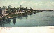
Leninskoye, settlement
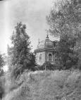
LENINSKOYE (Finnish Haapala before 1947), a settlement in Vyborg District. Population: 1800. Located on the bank of the Sestra River. The toponym Haapala originates from Haapanen, the name of the settlers who appeared in that area before the 17th... more
|
|
|
|
hidden
|
Lesogorsky, urban settlement
LESOGORSKY (Jaski before 1948, also Jaaski and Jaskis; Finnish Jääski), an urban settlement in Vyborg District. Population: 3,000. It is situated on the left bank of the Vuoksa River at the Kamennogorsk-Imatra railway branch. The name supposedly... more
|
|
|
|
hidden
|
Lisino-Korpus, settlement
LISINO-KORPUS, a settlement in Tosno District. Population: 1100. Located 2 km away from Lustovka railway station of the Fornosovo-Tyosovo-Netylsky branch on a highway connecting Tosno Town and Vyritsa urban settlement. The name is related to the... more
|
|
|
|
hidden
|
Listvenka, village
LISTVENKA, a village in Boksitogorsk District. Population: 34. Located on the right bank of the Kolp River. It is on the Olyeshi-Somino motor road having access to the Novaya Ladoga-Yaroslavl route. The village has a street-type planning. Several... more
|
|
|
|
hidden
|
Lodeynoye Pole District
LODEYNOYE POLE DISTRICT, a part of Leningrad Oblast located east of Lake Ladoga in the Svir River basin. In the north-west and north, it borders Olonets District of the Republic of Karelia; in the north-east and east, Podporozhye District; in the... more
|
|
|
|
hidden
|
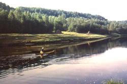
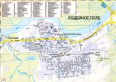
Lodeynoye Pole, town
LODEYNOYE POLE, town, adm. center of Lodeynoye Pole District. It is situated on the left bank of the Svir River. Population: 23,700. The Murmansk Highway extends across L. P., the town has a railway station on the Volkhovstroy-Petrozavodsk line... more
|
|
|
|
hidden
|
Lomonosov District
LOMONOSOV DISTRICT. Area: 1990.8 sq. km. Population: 65,300. Established in 1927. L. D. comprises Bolshaya Izhora and Lebyazhye urban settlements and 140 rural localities. It borders St. Petersburg and Kingisepp, Volosovo, and Gatchina Districts of... more
|
|
|
|
hidden
|
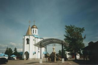
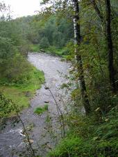
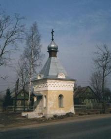
Losevo, settlement
LOSEVO (Finnish Kiviniemi before 1948), a settlement in Priozersk District. Located in the area known as Kiviniemi (“stone promontory”, Russian version: Kamenka) on the left (northern) bank of the arm connecting the Vuoksa River with Lake... more
|
|
|
|
hidden
|
Luga District
LUGA DISTRICT, municipal entity. Population: 44,600. Area: 5993.1 sq. km. Located in the south of Leningrad Oblast. In the west, it borders Slantsy District, in the north, Volosovo, Gatchina, and Tosno Districts of Leningrad Oblast; in the east,... more
|
|
|
|
hidden
|
Luga River, the
LUGA, river. It flows in Novgorod Oblast and in Luga, Volosovo, and Kingisepp Districts of Leningrad Oblast. Length: 353 km (the longest river in Leningrad Oblast.) Catchment area: 13,200 sq. km. Flow rate: 100 cu. m / s. Its width is 50-100 m in... more
|
|
|
|
hidden
|
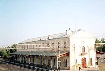
Luga, town
LUGA, town, adm. center of Luga District. Located 142 km (139 by railway) south of St. Petersburg on the Luga River, after which it was given its name. Population: 40,400. The town is a junction of motor and railroad routes to St. Petersburg,... more
|
|
|
|
hidden
|
Luzhitsi, village
LUZHITSI, a village in Kingisepp District. Population: 82. Located on the bank of the Luzhitsa River. First mentioned in the 1499/1500 Rent Census Book of Vodskaya Pyatina. In the 20th c., it integrated the villages of Nizhniye Luzhitsi, Glinki, and... more
|
|
|
|
hidden
|
Luzhsky Yam*, v. Luga, town
reference
|
|
|
hidden
|
Lyuban, town
LYUBAN, a town in Tosno District. Population: 4,600. It is situated on the Tigoda River. The town is crossed by the St. Petersburg-Moscow railroad line; it is connected to other localities of the district and oblast with motor roads. The town’s... more
|
|
|
|
hidden
|
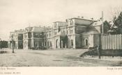
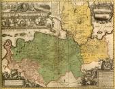
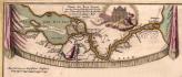
Maps and plans
MAPS AND PLANS. The oldest M.a .P. of the Leningrad Oblast area are dated 16th century. The Neva Land and the Karelian Isthmus with the towns of Noteborg (Schlusselburg) and Kexholm (Priozersk), although with many distortions, are presented in... more
|
|
|
|
hidden
|
Meleksa, village
MELEKSA, a village in Volkhov District. Population: 24. Located on the right bank of the Syas River. The name is of a Baltic Finnish origin. There is no information as to the date of its emergence. In the late 19th and early 20th century, carpenters... more
|
|
|
|
hidden
|
Melnikovo, settlement
MELNIKOVO (Finnish Räisälä before 1948), a settlement in Priozersk District. Population: 2100. Located on the banks of the northern branch of the Vuoksa River. In 1948, the settlement was renamed first Otradnoye, and then Melnikovo, in memory of... more
|
|
|
|
hidden
|
Mga River, the
MGA, a river, left-hand tributary of the Neva. Length: 55 km. Average flow rate in the mouth: 5.3 cu. m / s, catchment area: 709 sq. km. It flows out of Lake Maluksinskoye in the central part of Leningrad Oblast and it flows into the Neva within... more
|
|
|
|
hidden
|
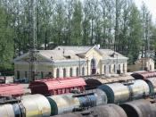
Mga, urban settlement
MGA, an urban settlement in Kirovsk District. Population: 9,600. The name originates from the Mga River on whose left bank the settlement is situated. M. has a favorable transport position as a large railway junction, having also access to... more
|
|
|
|
hidden
|
Michurinskoye, settlement
MICHURINSKOYE (Finnish Valkjarvi = “white lake” before 1948), a settlement in Priozersk District. Population: 2100. Located on the shore of Lake Michurinskoye (former Valkjarvi.) In 1948 it was successively renamed Belozerskoye, Krivko (in memory of... more
|
|
|
|
hidden
|
Mshinskaya, settlement
MSHINSKAYA, a settlement in Luga District. Population: 1,400. Located at Mshinskaya railway station of the St. Petersburg-Gatchina-Luga branch. The name is related to moss bogs. Around M. are waterlogged and swamp lands of international importance... more
|
|
|
|
hidden
|
Municipal Unions
MUNICIPAL ENTITIES, urban or rural (may comprise several united rural localities, such as a volost in Leningrad Oblast) – a settlement, municipal district, or urban area (and an intra-city area of a federal level city), where local government is... more
|
|
|
hidden
|
Murino, settlement
MURINO, a settlement in Vsevolozhsk District. Population: 5000. Located near the border of St. Petersburg on the bank of the Okhta River, at Devyatkino railway station and Devyatkino underground station. The village has been known since the early... more
|
|
|
|
hidden
|
Narova River, the
NAROVA (Narva, obsolete Estonian Alukse), river. Length: 77 km. Catchment area: 56,200 sq. km. Flow rate: 399 cu. m/s. It flows out of Lake Chudskoye and it flows into the Narva Bay of the Baltic Sea. N. is a borderline between Russian Federation... more
|
|
|
|
hidden
|
Naziya, urban settlement
NAZIYA, an urban settlement in Kirovsk District. Population: 5,800. It is situated in the central part of Leningrad Oblast on the banks of the Lava and Kovra rivers. It is connected with a motor road to the St. Petersburg-Novaya Ladoga highway.... more
|
|
|
hidden
|
Neuvola*, v. Gorkovskoye, settlement
reference
|
|
|
hidden
|
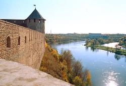
Neva River, the
NEVA, river in Leningrad Oblast and SPb. It was formed c. 3000 years ago due to a water breakthrough from Lake Ladoga to the Baltic Sea along the old valleys of the Mga and Tosna rivers. The toponym “Neva” is borrowed from the Baltic Finnish... more
|
|
|
|
hidden
|
Nikolskoye, town
NIKOLSKOYE, a town in Tosno District. Population: 17,300. It is situated on the Tosna River. 7 km north of N. is Ivanovskaya railway station on the St. Petersburg-Volkhovstroy line, and 6 km south-west of it, Sablino station on the St.... more
|
|
|
|
hidden
|
Nikolsky, urban settlement
NIKOLSKY, an urban settlement in the north-west of Podporozhye District. Population: 2,900. It is situated on a peninsula formed by a sharp bend of the Svir River. The name probably originates from the church of St. Nicholas the Miracle Worker... more
|
|
|
hidden
|
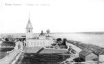
Novaya Ladoga, town
NOVAYA LADOGA, town in Volkhov District. Population: 10,000. Located in the central part of Leningrad Oblast in the Priladozhskaya Lowland, in the mouth of the Volkhov River, 25 km north of Volkhov Town. Administratively, the town also comprises... more
|
|
|